Date: Tuesday, December 21, 2010
Map: Link
Trails: Station Cove Falls, Oconee Connector
Distance: 4.5 miles
Time: 1 hour 40 minutes
Rating: 3 out of 5
Once Kerri returned from running, I went up to Oconee Station State Historic Site for a hike. It was about 2:20pm when I left, and I arrived at 3:00pm. I just headed up Highway 28 from Seneca, then took Highway 11 north. At the brown park sign I turned left, and the entrance to the SHS is a few miles ahead on the right. Unfortunately the gate was closed. I'm not sure why, unless it is just closed for the winter. There was no sign posted to explain the reason. Anyway, no big deal in this case. I just continued a couple hundred yards further down the road and parked at the trailhead for Station Cove Falls and the Oconee Connector of the Palmetto Trail.
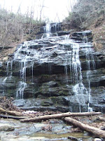
There were no other cars in the lot. It was cold and overcast. I started on the Station Cove Falls trail, which runs concurrent with the Oconee Connector. There are yellow blazes on the trees...very easy to follow. I followed the path over a couple of bridges to a hiker gate after about a half mile. I went through the gate, and in another quarter mile or so, there is a stream crossing and the falls are in view. I reached the falls in about 17 minutes without stopping. Not much water in the falls today, but then it hasn't rained much lately.

I stayed here for a few minutes, took some pictures and had a snack before turning around and heading back to the hiker gate. Here, I decided to turn left where the Oconee Connector leaves the Station Cove Falls trail, and heads uphill toward its other terminus at Oconee State Park.
This is really a very nice trail, better than I had expected. It moves steeply and relentlessly uphill with switchbacks, to a ridgeline. Once on the ridgeline, the terrain looks very much like Oconee State Park (mountain laurel everywhere). There are some views through the trees on both sides of the trail, with the best ones off to the right. As I approached the ridge, it started to rain lightly, but I had come prepared with a rain jacket. I also had my hiking pole, which helped a lot with the uphill climb over wet leaves.
At each mile along the trail, there are signposts, with a mile number representing how far you've come from the trailhead you left. I passed Mile 1, and then I came to another marker that had Mile 2 showing on the opposite side, meaning that I was still two miles from the other trailhead. I stopped at this marker, and returned back the way I had come, in the interest of time. By my estimate, I hiked about a mile and half on the Oconee Connector after leaving the Station Cove Falls trail, although I can't really line that up with the posted mile markers.

I returned to the car at about 4:40pm. A very enjoyable hike, and I really had a good time on the Oconee Connector. I would be interested in doing the whole trail at some point in the future, if I'll allow more time for it. Even though it is a slightly longer drive, I decided to head home by continuing north on Hwy 11 and turning right onto Hwy 133 to Clemson. This was a more relaxing drive than going through Seneca at 5pm on a weekday before Christmas.
No comments:
Post a Comment